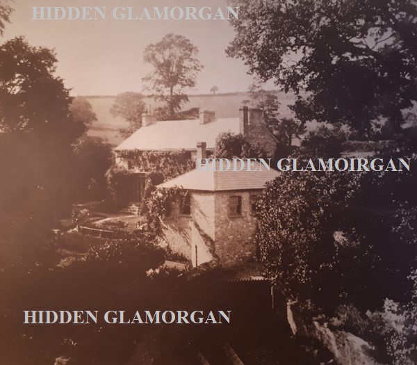
As most readers will already know, Barry as a town began its existence within the last few decades of the nineteenth century. Before the construction of the docks and accompanying urbanisation of Barry’s coastline, Barry was little more than a small rural village with a population of around one hundred people. The coastline of Barry and its surrounding countryside contained little more than a few isolated villages and the occasional farmstead.
(Photograph showing the construction of Barry Docks with the undeveloped countryside in the background-People's Collection Wales)
Barry as a town has grown exponentially since its Victorian inception. It is possible to trace this urban growth and outwards expansion by looking at Barry’s architecture. First came the Victorian buildings, which for the most part are concentrated around the coastline near the docks. Grand public buildings such as the docks offices and the town hall stand as a prominent reminder of Barry town’s Victorian origins when coal from Barry was exported worldwide-and Barry was the busiest port in the world. Barry’s numerous institutes and clubs, pubs and hotels were constructed to cater for its new communities and the sailors who docked at Barry. Many of the commodious mansions of the middle-classes were built around the peripheries-in particular, the west-end of Barry. And of course the ubiquitous red-brick terraced houses which tend to characterise Barry mushroomed around the port and dock nucleus of this new town.
(Western Square late nineteenth century showing the recently constructed buildings and street layout. This type of development of housing intermixed with hotels and shops tends to characterize the late Victorian town of Barry-People's Collection Wales)
During post-war Britain, the demand for coal fell,
and the once busiest port in the world slid into terminal decline. Many of Barry’s
architecturally fine dockland buildings became neglected and rundown, and a
good number of them were sadly demolished-but the town it seems was set to expand.
Despite the lack of new industry and jobs within Barry the civic authorities
decided that the countryside surrounding Barry would be a suitable place to enlarge
the municipality by constructing a series of massive housing estates. These
housing estates consumed much of the open countryside which lay on the
peripheries of the initial Victorian development.
The land around the village of Merthyr Dyfan was for example in the 1950’s utilised for a housing development. Within the subsequent decades after the initial development, yet more houses were constructed within the vicinity of Merthyr Dyfan and in many other places on Barry’s boundaries. The die had been cast-and the town of Barry was set to expand, seemingly indefinitely. This rapid urbanisation has seen the disappearance of almost all of the green spaces and countryside within and surrounding the Barry area and thus-in piecemeal fashion, the boundary of Barry’s urban sprawl has been pushed ever further from its late Victorian origin with Port Road now demarcating the extent of Barry’s urbanisation until the green undulation of the Vale of Glamorgan begins proper.
(Photograph circa mid twentieth century showing gradual encroachment and urbanisation of Barry in the Gibsonsdown area-People's Collection Wales)
Many people will know that the majority of the
districts within Barry were already small-but thriving communities before the
late nineteenth century and have histories that stretch back hundreds of years.
Reminders of Barry’s ancient past, such as Barry castle, Cadoxton Court
dovecote and a number of medieval churches lie scattered throughout the town. Many
people like us, wonder what Barry before Barry looked like. This article will
go some way towards fulfilling this interest, and show the reader Barry as
they’ve never seen it before.
View of Western Hill Cadoxton from Cadoxton Moors early twentieth century-People's Collection Wales
(Merthyr Dyfan church circa 1900. With the exception of a lone house there is little in the way of development within the vicinity)
(Romilly Park circa 1910. The landscape, which by and large appears to be free from enclosures, would not have changed a great deal since the medieval period until the area was landscaped into Romilly Park. The Tudor period Castle Farm can be seen at the top of the picture-People's Collection Wales)
(The final picture in our tour of old Barry shows Romilly Park shortly before landscaping. Much of the housing at the west end of Barry has yet to be constructed)
Mark and Jonathan Lambert are writers based in the Vale of Glamorgan. They are both archaeology graduates of Cardiff University and have written a number of books. They have been writing about and researching local history for the past 20 years. All articles are original compositions - we hope you enjoy our content.
Enquiries: hiddenglamorgan@outlook.com
©Jonathan and Mark Lambert 2021
The right of Jonathan and Mark Lambert to be identified as Authors of this work has been asserted in accordance with the Copyrights, Designs and Patents Act 1988. All rights reserved. No part of this article may be reprinted, reproduced or utilised in any form or by any electronic means, including social media, or mechanical, or by any other means including photocopying and recording, or in any information storage or retrieval system, without permission in writing from the authors.


%201.jpg)

%201.jpg)


%201.jpg)

%201.jpg)

%201.jpg)


This is excellent. I was born and brought up in Station Street and vividly remember the coal trains offloading at the docks. My father was born at Clive Road, Barry Island. Absolutely great to see these photographs. Have not gone far....living in Sully for past 25 years.
ReplyDelete